ROAR - Explaining the Map of Dreams
There's not much the WildEast's Dr Sarah Taigel doesn't know about maps.
She has spent the past 25 years working to refine and simplify how landscape scale nature recovery can be mapped at a local level.
For the pledgees of WildEast this means mapping (for the first time) the nature recovery happening in our own villages and how this can be increased and connected.

Twenty five years ago when I began my geospatial career very few people understood what it was that my work involved; the best description I could offer was maps on computers and more than one person I knew said it would never take off. In all fairness the job of geographical information system (GIS) analyst in the early days involved far more computer support than any geographical science. Since then the incredible explosion of technology has meant that explaining what I do has become easier as more people become spatially literate. The software and concepts behind the Map of Dreams are similar to the satellite navigation system in your car or the logistics planning tools used by Amazon delivery drivers – that is they all use a geospatial approach to solve problems.
What makes Wild East unique for a small organisation is that right from the outset they have embraced geospatial technology understanding that knowing where people are making space for nature is equally as important as knowing what people are doing. Everyone can contribute (pledge) with specific pathways for different types of land user. Partner organisations and land owners can follow one path and those responsible for their own patch of green space; be that garden, allotment or woodland, can follow another. All those pledges end up in the same database and on the same map showing where nature is being allowed to thrive in East Anglia.
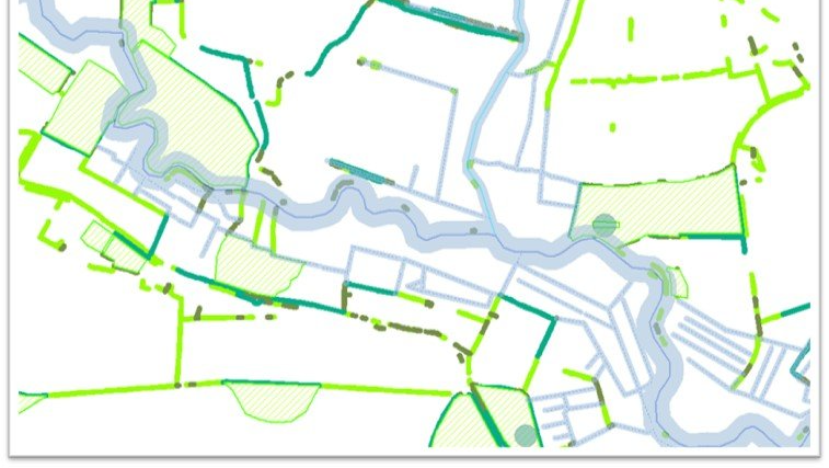
What does Geospatial mean?
Geospatial relates both to data and to technologies which have a geographic component. A GIS stores many different data layers, each representing a different element of the landscape. In the example on the right street data, building data and vegetation data is overlaid to show land use in an area. Organisations which use a GIS and/or spatial data to inform decisions and assist in communicating solutions can be said to be taking a geospatial approach; particularly beneficial when working across varying scales with a wide range of partners.
Figure 2 - What is GIS?
Making the Wild East Basemap
A GIS (or geographical information system) allows data with a geographical component to be created, stored, manipulated, analysed and visualised. Initially I was asked by the WildEast team to determine whether there were any open source maps or datasets for the WildEast region that identified where landscape features which were vital for nature connectivity existed (woodlands, hedges and water bodies). It was no surprise that datasets covering the whole Wild East region did not exist and so using a combination of open source and data licensed from Natural England over four million features were brought together in a new baseline map (indicating which areas are biodiversity rich).
After discussions with other experts these datasets were extended using geospatial tools. For example buffers were generated to show the area that healthy wild edges needed. Working with UCL and Professor Carl Sayer variable buffers were designed for water features such as streams, ditches and main rivers (to show aspirational map of restoration potential). Woodlands were analysed to show where in the WildEast region woodlands were most fragmented. Using techniques developed while I was at the UEA the data layers were combined across the whole WildEast region resulting in a basemap map which showed where nature most needed space.
The WildEast base map alongside the pledges and the large pledges from partners is now brought together on the WildEast Map of Dreams. The hope is that the mapping can support initiatives in different sectors and at different scales. First at a supra regional scale we have a story map showcasing large scale ‘re wild’ and landscape scale projects within the WildEast region, a summary of each project is given with weblinks for more information. These large landscape scale projects such as that at Wild Ken Hill or Somerleyton often showcase the best of multifunctional landscapes, evidencing how with care and planning a sustainable landscape can be created which balances food production, species reintroduction and biodiversity

Then at a more regional scale the pledge data from everyone working to make the WildEast wild again can be visualized on maps in a multitude of ways. GIS tools can be used to highlight where villages or communities are working together by analysing the degree to which pledges are clustered. Alongside that analysis the amount of land which people are pledging can also be evaluated and the sum of the areas give an indication of how close the Wild East project is to its overall target of 250,0000ha by 2050.
Lastly the third example shows how the map of dreams base layer is supporting WildEast in their partnership with Natural England and Suffolk County Council to create a toolkit for parishes wanting to make their area more biodiverse with greater nature connectivity.
What can you do?
After feedback from stakeholders and pledgees the WildEast pledge form has been updated making it easier to use. When thinking about how you might pledge space to nature think of the elements in your garden which wildlife and nature can enjoy, winter is the perfect time to plan for Spring and new ideas. There are many tips on the WildEast blog as well as case studies from pledges which highlight what each and everyone of us can do with our outside space.
Sarah Taigel (Phd, MSc, FRGS)
Geographer, geospatial expert and chalk river friend, 25years experience of geospatial analysis, development and data management. Broad range of geospatial and landscape scale mapping skills with a focus on assisting community scale projects to incorporate geospatial thinking. Award winning PhD at the UEA focused on how GIS and associated technologies could support landscape scale management – in particular chalk river catchments. Lots of participatory practice, stakeholder engagement and citizen science, fly drones and volunteer data skill for the rivers trust in my spare time.
WildEast Blog